| Home | Main Menu |
|
|
LongyearbyenSpitsbergen, Svalbard, Norway
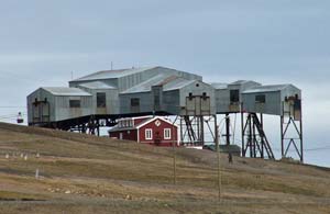
ABOVE: Longyearbyen's aerial-cableway terminal once gathered coal from 6 km of mine conveyors for delivery to the port below. Location and historyLocationLongyearbyen is on the Adventsfjord, an inlet where the Adventdal River meets the Isfjord or "Ice Fjord" on the western side of Spitsbergen. The town lies at a latitude of 78º N, within 600 miles or 966 km of the North Pole. Thanks to the Gulf Stream, which warms the western coastline of Spitsbergen, Longyearbyen has a relatively mild climate for a town that's closer to the North Pole than to the Arctic Circle (which lies 800 miles or 1260 km to the south). The average daily temperature in July is 43º F or 6º C. In January, Longyearbyen averages a toasty 3º F or -16º C, though winds can make it feel colder.
HistoryLongyearbyen is the only self-governing municipality in Svalbard, a remote Arctic island group with a recorded history that dates back more than 800 years. According to Spitsbergen Travel, Svalbard means "the land with the cold coasts" and was first mentioned in Icelandic annals in 1194. In 1596, a Dutch expedition led by Wilhelm Barentsz arrived in Svalbard and named the region "Spitsbergen," a name that meant "sharp, pointed mountains." Today, Spitsbergen, often spelled "Spitzbergen," is the name of the largest island. During the 400 years after its discovery by Wilhelm Barentz, Svalbard was a whaling and hunting ground for the Dutch, English, Russian Pomors, and Norwegians. Whales, walruses, and other species were hunted nearly to the point of extinction. (Today, walruses and polar bears are protected by law, though Norway continues to practice commercial whaling.)
Svalbard has been under Norwegian sovereignty and administration only since 1925, when the Svalbard Treaty took effect. This treaty, which has been signed by 40 nations, gives all citizens of all participating nations equal rights of residence, work, and trade in the territory. Longyearbyen todayFor much of the 20th Century, Svalbard was off-limits to general tourism, and for good reason: The territory was extremely isolated, with poor communications and non-existent transportation for much of the year. In the late 1980s, nearly 15 years after the opening of Longyearbyen's airport, tourism resumed. Today, visitors come to Longyearbyen and Svalbard year-round, cruise ships arrive in the summertime, and Longyearbyen is a popular starting point for wildnerness treks and adventure cruises. Still, the town and region are far off the usual tourist path, and Longyearbyen probably gets fewer tourists in a year than a city like Venice receives in a day. Next page: Sights and excursions
|
|
|
| Europe for Visitors - Home | | About us | | Press clippings | | Testimonials | Copyright © 1996-2024 Durant and Cheryl Imboden. All rights reserved. |
 If
you're visiting in summer, the "Midnight Sun" can be disconcerting: The sun
doesn't set from April 20 until August 23, and you may find it difficult to go
to bed when the wee hours look like high noon. (The small photo at left was
taken around 3 a.m.) Still, if you're a night owl, you can always visit in
winter, when the "Polar Night" keeps the sun below the horizon from November 14
to January 29.
If
you're visiting in summer, the "Midnight Sun" can be disconcerting: The sun
doesn't set from April 20 until August 23, and you may find it difficult to go
to bed when the wee hours look like high noon. (The small photo at left was
taken around 3 a.m.) Still, if you're a night owl, you can always visit in
winter, when the "Polar Night" keeps the sun below the horizon from November 14
to January 29. Polar
research and tourism began in the 19th Century, and in the 20th Century,
coal
mining began in the region. Longyearbyen ("Longyear City") is named after John
M. Longyear, an American businessman who began mining operations in 1906. The
Store Norske
Spitsbergen Grubecompani continues to mine coal in Longyearbyen and in Svea,
60 km away. (The local mining staff numbers about 20, and coal is used mostly in
the Longyearbyen power plant.)
Polar
research and tourism began in the 19th Century, and in the 20th Century,
coal
mining began in the region. Longyearbyen ("Longyear City") is named after John
M. Longyear, an American businessman who began mining operations in 1906. The
Store Norske
Spitsbergen Grubecompani continues to mine coal in Longyearbyen and in Svea,
60 km away. (The local mining staff numbers about 20, and coal is used mostly in
the Longyearbyen power plant.)