| Germany Index | Europe for Visitors |
|
|
Getting to WolfsburgFrom: Volkswagen's Autostadt
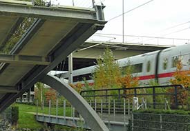
ABOVE: An ICE train of the German Federal Railways passes the seesaw bridge at VW's All-Terrain Track. Arriving and departingBy train: Wolfsburg is just over an hour from Berlin's main railroad station by high-speed ICE train. (Normal trains take a bit longer.) Plan your journey with the Deutsche Bahn's interactive timetable. When you arrive in Wolfsburg, walk across the StadtBrücke or City Bridge to the Autostadt (which shouldn't take longer than 7 to 10 minutes) or hire a cab at the train station. By car: Wolfsburg is 87 km or 54 miles east of Hannover, just north of the A2 Autobahn on the A39 connector from Braunschweig. Get maps and directions online from ViaMichelin. As you approach Wolfsburg, follow the signs to the Autostadt and its parking lots. By boat: From spring through fall, hotel barges and river-cruise ships occasionally stop in Wolfsburg, which is on the Mittelland Canal between Dortmund-Ems and the Elbe (a distance of 321 km or 199 miles). For more visitor information:See the Autostadt and Lower Saxony: Wolfsburg Web sites. Next page: Hotel Ritz-Carlton, Wolfsburg
|
|
|
| Germany for Visitors - Home | | Europe for Visitors - Home | | About us | | Press clippings | | Testimonials | Disclosure: Where hotel or other reservation links point to third-party booking sites, we may receive a small commission on transactions. This will not affect the rate you pay. Copyright © 1996-2026 Durant and Cheryl Imboden. All rights reserved. |