|
|
| Venice Home | All topics |
| Where to stay | Transportation |

|
|
Venice Marco Polo Airport Aerial Photo MapFrom: Venice Marco Polo Airport
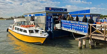
ABOVE: An Alilaguna water bus at Marco Polo Airport. The Google satellite photo below will display best on a desktop computer, a laptop, or a full-size tablet such as the iPad or iPad Mini. On the map, you'll see Venice Marco Polo Airport's main terminal building (large rectangle) with the water taxi and Alilaguna airport boat piers along the water. Ground transportation:
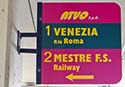
The Mestre "Fly Bus" to Venezia Mestre Railroad Station also leaves from the lower level of the building. Water transportation:Piers for water taxis and Alilaguna airport water buses are about 10 minutes from the terminal via a moving sidewalk. (Look for signs as you exit on the arrivals level.) Map (zoom for a closer view): |
|
|
| Venice for Visitors - Home | | Europe for Visitors - Home | | About our site | | Press clippings | | Testimonials |
Disclosure: Where hotel or other reservation links point to third-party booking sites, we may receive a small commission on transactions. This will not affect the rate you pay. Copyright © 1996-2026 Durant and Cheryl Imboden. All rights reserved. |