Venice > Sightseeing >
Top 11 free sights > St. Mark's Basin
Venice's Waterfront
(St. Mark's Basin)
From:
Venice's Top 11 Free Sights
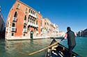
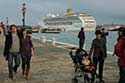
ABOVE: A view of St. Mark's Basin after a 15- or
20-minute stroll up the waterfront promenade, with the bell towers of San
Giorgio Maggiore on the left and San Marco on the right.
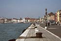 As
you leave the Piazza San Marco and the Piazzetta (the branch of St. Mark's
Square that leads past the Doge's Palace to the water), turn left and follow the
Riva degli Schiavoni, the first section of the waterfront promenade that runs
continuously (with several name changes) to the Giardini Pubblici park and
beyond. As
you leave the Piazza San Marco and the Piazzetta (the branch of St. Mark's
Square that leads past the Doge's Palace to the water), turn left and follow the
Riva degli Schiavoni, the first section of the waterfront promenade that runs
continuously (with several name changes) to the Giardini Pubblici park and
beyond.
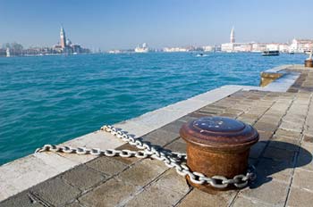
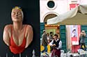
 Along
the way, you'll pass the San Zaccaria and Pietà waterbus platforms. San Zaccaria
(sometimes abbreviated to "Zaccaria") is a major stop for several
ACTV vaporetto lines; Pietà (shown in the inset photo) is the turnaround
station for double-deck pedestrian ferries that connect central Venice with
suburbs on the Lido and points beyond. Along
the way, you'll pass the San Zaccaria and Pietà waterbus platforms. San Zaccaria
(sometimes abbreviated to "Zaccaria") is a major stop for several
ACTV vaporetto lines; Pietà (shown in the inset photo) is the turnaround
station for double-deck pedestrian ferries that connect central Venice with
suburbs on the Lido and points beyond.
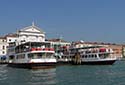
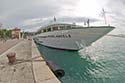 If
you're lucky, you may see one or more ships tied up along the waterfront:
possibly a river vessel like CroisiEurope's Michelangelo (shown at
right), or perhaps a yacht, a sailing ship like the Italian Naval Academy's
Amerigo Vespucci, or a small ocean cruiser. If
you're lucky, you may see one or more ships tied up along the waterfront:
possibly a river vessel like CroisiEurope's Michelangelo (shown at
right), or perhaps a yacht, a sailing ship like the Italian Naval Academy's
Amerigo Vespucci, or a small ocean cruiser.
 You'll
also pass hotels, cafés, exhibition venues, and--after 15 or 20 minutes--the
site behind the public gardens where the Biennale di Venezia art exhibition
takes place during odd-numbered years. You'll
also pass hotels, cafés, exhibition venues, and--after 15 or 20 minutes--the
site behind the public gardens where the Biennale di Venezia art exhibition
takes place during odd-numbered years.
Unless you're pressed for time, keep going until you reach Sant'Elena, a
relatively modern 19th and early 20th Century residential neighborhood with
parks, the city's football stadium, and a marina.
Another waterfront itinerary:
-
Cross the Accademia Bridge
from San Marco to the sestiere or district of Dorsoduro. Bear left
as you leave the bridge and follow the main tourist thoroughfare to the
imposing
Santa Maria della Salute Church,
which is worth a quick visit. (Admission is free.)
-
 From
the Salute church, walk the short distance along the water to the scenic
viewpoint at Dogana di Mare, continue
around the tip of the island, and follow the wide promenade called the
Zattere along the Giudecca Canal. (You'll see plenty of water
traffic including vaporetti,
motoscafi, cargo boats, local
car ferries, year-round cargo and passenger ferrie to Greece,
and--during the warmer months--cruise ships,
which traverse the Giudecca Canal on their way to and from the Marittima
and San Basilio cruise terminals. From
the Salute church, walk the short distance along the water to the scenic
viewpoint at Dogana di Mare, continue
around the tip of the island, and follow the wide promenade called the
Zattere along the Giudecca Canal. (You'll see plenty of water
traffic including vaporetti,
motoscafi, cargo boats, local
car ferries, year-round cargo and passenger ferrie to Greece,
and--during the warmer months--cruise ships,
which traverse the Giudecca Canal on their way to and from the Marittima
and San Basilio cruise terminals.
Next page:
Grand Canal
About the author:
 Durant Imboden has
written about Venice, Italy since 1996.
He covered Venice and European travel at About.com for 4-1/2 years before launching
Europe for Visitors (including
Venice for Visitors) with Cheryl
Imboden in 2001. Durant Imboden has
written about Venice, Italy since 1996.
He covered Venice and European travel at About.com for 4-1/2 years before launching
Europe for Visitors (including
Venice for Visitors) with Cheryl
Imboden in 2001.
PC Magazine has called this "the premier visitors'
site for Venice, Italy." Over the years, it has helped more than 30 million
travelers. For more information, see About our site,
our Europe for Visitors
press clippings,
and
our reader testimonials.
Top photo copyright © Steve Geer.
| |
|