|
|
| Venice Home | All topics |
| Where to stay | Transportation |

|
|
Acqua AltaHigh Tides and Flooding in Venice, Italy
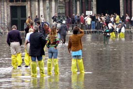
ABOVE: Pedestrians cross Venice's Piazza San Marco on temporary passerelle during acqua alta. (Thanks to the new MOSE tidal barrier, scenes like this should be less common in the future.)
Acqua alta, or "high water," can make Venice feel like Atlantis. At its worst, in 1966, acqua alta flooded the city with more than a meter of salty lagoon water; more typically, visitors notice water splashing over canal banks or bubbling up through drains in the Piazza San Marco. The phenomenon is often mistaken for proof that Venice is sinking. Although the city did sink about 10 cm in the 20th Century because of industrial groundwater extraction, the sinking largely stopped when artesian wells on the mainland were capped in the 1960s. Today, subsidence is estimated at 0.5 to 1 mm per year, mostly due to geological factors and compression of the land beneath the city's millions of wooden pilings. A larger problem is the rising sea level, which will become an even bigger threat as global warming melts the arctic ice caps. Already, the frequency of acqua alta has increased from fewer than 10 times a year to more than 60 times a year in the last century.
PHOTOS: Intrepid tourists wade in the Piazza San Marco. Why (and when) acqua alta floods the city:Acqua alta occurs when certain events coincide, such as:
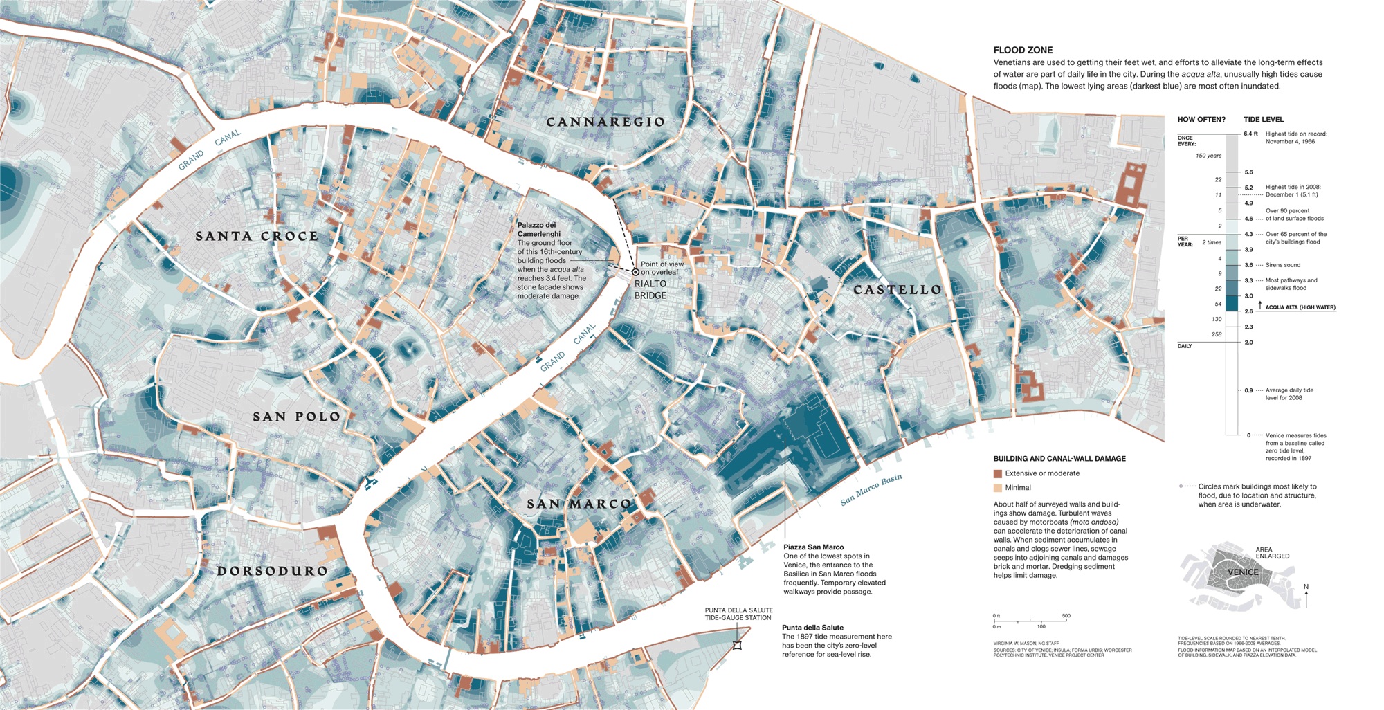
The phenomenon is most likely to take place between late September and April, and especially in the months of November, December, and October, in that order. However, thanks to global warming, it now can occur at any time of year. Not all parts of the city are equally susceptible to flooding, as the following chart from the Comune di Venezia indicates. Also, the actual depth of water in the streets is far less than the "level of tide" might suggest. (See the "extreme case" below, where 135 cm of flooding translated into 40 cm of water in the Piazza San Marco.)
An extreme case:On the October day when some of the photos in this article were taken, the acqua alta reached 135 cm. The Piazza San Marco was inundated by at least 40 cm or 16 inches of water in what was billed as the worst acqua alta of the decade. Several times during early winter in the last few years, acqua alta has reached 150+ cm or higher and flooded most of the city. The worst deluge in Venice's history was in 1966, when floodwaters topped out at 194 centimeters. The second-worst was in November, 2019, when the waters reached 187 centimeters. Fortunately, the city has made changes over the years to ameliorate the effects of acqua alta. For example, electrical substations have been moved out of harm's way, and ground-floor wiring is now installed high enough on walls to prevent short circuits in most cases. Thanks to such changes, the 2019 flooding didn't result in massive power outages (which left the city without electricity for days in 1966). Possible solutions:The Comune di Venezia and various international organizations have been working on solutions that range from MOSE Project floodgates at the Lagoon's entrances to raising of pavements in low-lying areas of the city. On October 3, 2020, Venice activated its new MOSE tidal barrier against an acqua alta flood for the first time. MOSE successfully blocked a 129-cm tide, and even the Piazza San Marco--the lowest-lying area of the city--remained flood-free. Since then, it has been deployed dozens of times with equal success, although rising sea levels may make it obsolete several decades from now. (Also, MOSE doesn't protect against minor nuisance flooding, since it's activated only under severe conditions.)
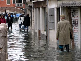
ABOVE: A flooded fondamenta in Dorsorduro, between the San Basilio vaporetto stop and the Campo Santa Margherita. What to expect during acqua alta:Most of the time, acqua alta is only a mild nuisance: You might have to sidestep a pond or two in the Piazza San Marco or avoid water that's splashing onto a fondamenta, or sidewalk, next to a canal. However, if you hear a siren wailing, you should be prepared for more serious flooding, especially in low-lying areas of the historic center. A siren means that an unusually high tide will peak in three to four hours. Depending on the height of the acqua alta and where you are in the city, you could encounter flooding for several hours before and after the tidal maximum. Such flooding can vary from a few centimeters to a major inundation like the one in the picture above. (It's worth noting that Venice's Tidal Center claims that its three-hour forecasts are 95% reliable, with an accuracy of plus or minus 10 centimeters.) The city provides elevated wooden walkways in areas of the city that are prone to flooding; you can see a map of these pedestrian routes at most ACTV vaporetto stops. How to prepare:If you plan to spend time in Venice during the fall and winter months, you may want to pack rubber boots--especially for visits near the full moon or new moon, when acqua alta is most likely to occur. Alternatively, consider packing several plastic garbage bags and strings or elastic bands to hold them in place. Garbage bags may not be elegant, but they can help to keep your shoes and legs dry. Another option is to buy rubber boots in Venice or acquire temporary plastic rain boots from souvenir stands and street vendors. However, if you have large feet, you may have trouble finding boots that fit--and in any case, you'll need to buy protection before the waters rise. Again, it's unlikely that acqua alta will be more than a mild nuisance during your stay, and it isn't a danger to human life. (No one drowned during the record acqua alta of 1966, when the entire city was flooded.)
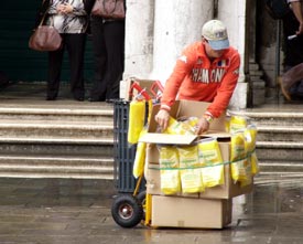
ABOVE: Plastic boots for sale in the Piazza San Marco. Acqua alta Web links
Venice
Travel Blog: Acqua Alta
City of Venice: Acqua Alta (High Tide
Forecast)
Acqua Alta:
Flood Zone
hi!tide Venice app (Android or
iOS) 
Venice for first-time visitors:
The
flood, the aftermath
Mail Online: The Floating City Videos
Venice keeps flooding: How an engineer would solve it Also see YouTube's acqua alta videos, some of which show dramatic scenes from before MOSE's implementation. (This page will open in a new browser tab.) Next page: Acqua alta photos - Dorsoduro
|
|
|
| Venice for Visitors - Home | | Europe for Visitors - Home | | About our site | | Press clippings | | Testimonials |
Disclosure: Where hotel or other reservation links point to third-party booking sites, we may receive a small commission on transactions. This will not affect the rate you pay. Copyright © 1996-2025 Durant and Cheryl Imboden. All rights reserved. |


