| Madrid Index | Europe Home |
|
|
Madrid, SpainPage 10
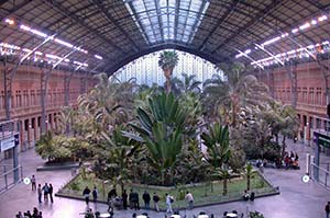
ABOVE: The tropical garden in Madrid's Atocha railroad station. INSET BELOW: Terminal 1 of Barajas Airport. Transportation
Ground transportation includes the Metro (see below), taxis, and buses or shuttles. The Metro takes about 40 minutes to downtown with one or two train changes; the Airport Express bus takes about the same time, depending on traffic, but is more convenient than the Metro when you're traveling with bulky luggage at rush hour. Railroads. Madrid has two long-distance railway stations: Charmartin, in the northern part of the city, handles traffic from the north and east, including France. The popular Lisbon-Madrid Night Train arrives and departs at this station, which has frequent and quick local train connections to:
Long-distance buses. Eurolines connects Madrid with cities throughout Europe, with buses arriving and departing at the Estación Sur de Autobuses in the southeastern part of the city. (You can reach the city center by Metro from the Méndez Alvaro stop on the #6 circular line.) A few smaller bus lines use their own stations; see Gomadrid's transport page for station addresses. Arriving by car. Madrid is in the center of Spain, so it's easy to reach by motorway from nearly any direction. Use ViaMichelin to plan your driving trip. Once you've arrived, you'll need to park (which can be tricky in the city center), so consult with your hotel beforehand and rely on public transportation once you're in town. Local transportation:
Public buses. The local bus network is run by EMT Madrid. Buses operate from 6 a.m. until midnight. You can buy a discounted 10-journey Bono from any Metro station or bus information booth, and it--like single-journey transit tickets--can be used for either underground or bus travel. If you plan to travel extensively by Metro or bus, consider buying a Tourist Travel Pass (Abono Transportes Turístico), which permits unlimited travel for 1, 2, 3, 5, or 7 calendar days. (Get the cheaper Zone A version unless you plan extensive suburban travel.)
TheMadridVision buses won't take you anywhere that you couldn't reach by public transportation--or, in the case of historic Madrid, on foot--but if you're on a tight schedule or want to minimize walking, they can be a good value. (You can ride MadridVision buses free with the Madrid Card; the Madrid Card Cultura provides a 10% discount.) Next page: Tourist information |
|
|
| Europe for Visitors - Home | | Contact information, disclosures, audience | Disclosure: Where hotel or other reservation links point to third-party booking sites, we may receive a small commission on transactions. This will not affect the rate you pay. Copyright © 1996-2026 Durant and Cheryl Imboden. All rights reserved. |

 The
The