The
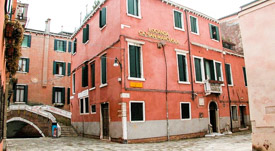
Locanda Ca' San Marcuola is a guest house on a small, quiet square
just off the Grand Canal. It's close to the San Marcuola vaporetto stop,
but--more important if you're on a budget--it's within walking distance of the
Guglie airport-boat stop and the Santa Lucia railroad station.
All 12 rooms at the Locanda Ca' San Marcuola
are air-conditioned and have private bathrooms. Wi-Fi is free.
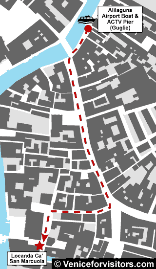
How to reach the Locanda Ca' San Marcuola from the
Guglie airport-boat stop (Alilaguna Linea Arancio):
As you leave the boat platform, turn right.
Walk to the Ponte delle Guglie (a stone bridge that spans
the Cannaregio Canal). Turn left at the foot of the bridge.
Walk on the Rio Terà S. Leonardo until it curves
sharply and becomes the Rio Terà Farsetti. Look for signs that direct you to
the San Marcuola vaporetto stop and the San Marcuola traghetto pier.
Follow the signs to the Campo San Marcuola, where you'll
find the Locanda Ca' San Marcuola on the east side of the square, to the
right of the church.
For a video alternative to these directions,
click below:
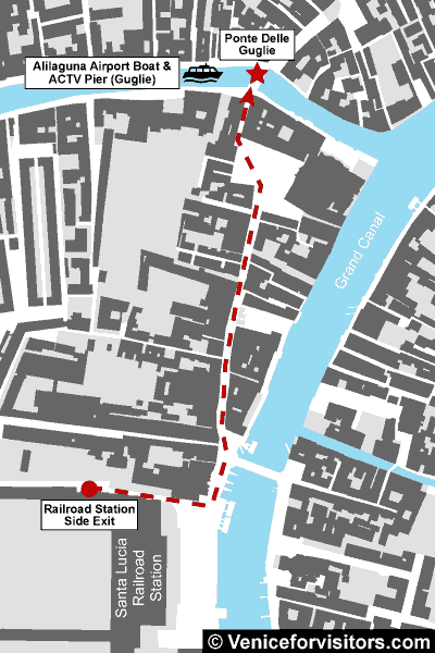
From the Santa Lucia Railroad Station:
ABOVE: This map shows the route from Venezia
Santa Lucia Railroad Station to the Ponte delle Guglie on the Cannaregio Canal.
Walking time is 5 to 10 minutes over level ground.
Leave the railroad station by the marble steps outside the main doors,
or by the side exit near Track 1 if you have rolling luggage, a stroller, or a
wheelchair and want to avoid stairs.
When you reach the wide fondamenta or pavement in
front of the station, turn left.
Walk past the Scalzi Church and the Scalzi Bridge toward the
Rio Terà Lista di Spagna (a busy shopping street).
Continue down the Lista di Spagna and through the Campo San
Geremia to the Ponte delle Guglie, which is a stone bridge over the
Cannaregio Canal.
Cross the bridge.
Continue straight ahead on the Rio Terà Leonardo until it
curves sharply and becomes the Rio Terà Farsetti. Look for signs that direct
you to the San Marcuola vaporetto stop and the San Marcuola traghetto pier.
Follow the signs to the Campo San Marcuola, where you'll
find the Locanda Ca' San Marcuola on the east side of the square, to the
right of the church.
Durant Imboden has
written about Venice, Italy since 1996.
He covered Venice and European travel at About.com for 4-1/2 years before launching
Europe for Visitors (including
Venice for Visitors) with Cheryl
Imboden in 2001.
PC Magazine has called this "the premier visitors'
site for Venice, Italy." Over the years, it has helped more than 30 million
travelers. For more information, see About our site,
our Europe for Visitors
press clippings,
and
our reader testimonials.
Where hotel or other reservation links point
to third-party booking sites, we may receive a small commission on transactions.
This will not affect the rate you pay.