|
|
| Home | Sightseeing |
| Transportation | Cruise Port |
|
|
Civitavecchia City GuidePage 4
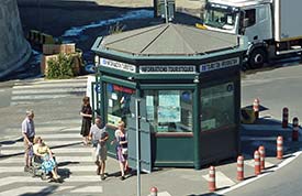
ABOVE: Civitavecchia's tourist office has an information booth at the south entrance to the cruise and ferry port. Civitavecchia transportation and tourist informationHow to reach the city and port
See our Rome to Civitavecchia by Train and Civitavecchia to Rome by Train articles for details. By car. Civitavecchia is on the western coast of Italy, about 80 km or 50 miles northwest of Rome and straight up the coast from Fiumicino (the site of Leonardo da Vinci Airport). For maps and road directions, go to Google Maps or the ViaMichelin journey planner.
By bus. Cotral operates buses to Civitavecchia and neighboring towns. (We recommend sticking with the train unless you have a compelling reason to travel by bus.)
Tourist information
Another useful resource is the Google satellite photo map of Civitavecchia, which provides a clear aerial overview of the city center. (In the default view, you'll see the Forte Michelangelo and the port entrance on the left, with the main waterfront promenade along the beaches and the railroad station on the right.) Back to: Civitavecchia - Index
|
|
|
| Europe for Visitors - Home | | About us | | Press clippings | | Testimonials | Disclosure: Where hotel or other reservation links point to third-party booking sites, we may receive a small commission on transactions. This will not affect the rate you pay. Copyright © 1996-2026 Durant and Cheryl Imboden. All rights reserved. |
 By
ferry.
By
ferry. By
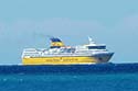
cruise ship.
By
cruise ship. 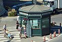 Civitavecchia's